
Garmin eTrex SE
4.2Editor score
Long battery life
Water resistant design
Multi-GNSS support
Navigating the open water requires reliable technology to ensure safety and efficiency. A handheld GPS for boating provides essential location tracking, route planning, and emergency features. These devices help mariners stay on course and avoid hazards while exploring coastal or inland waters.
We evaluated ten top-rated models based on durability, display quality, satellite support, and marine-specific features. Each unit was analyzed for its ability to withstand water exposure and provide accurate positioning. This list covers a range of options from entry-level navigators to advanced marine tools.
Each pick highlights key strengths like floating design, chart preloading, and battery longevity. Prices and availability may change over time so verify details before purchasing. Use this guide to find the device that fits your specific boating style and navigation needs.
4.2Editor score

4.0Editor score
4.2Editor score
As an Amazon Associate we earn from qualifying purchases.
This table compares the ten best handheld GPS options for boating by key specifications and features to help you choose the right navigation tool for your vessel.



The Garmin GPSMAP 79sc stands out as the premier choice for serious boaters who need marine-grade reliability. It carries a strong 4.0 rating from users who value its rugged build and precise navigation tools. This device combines floating capability with preloaded BlueChart g3 coastal charts for immediate use.
We may earn a commission when you buy through this link, at no additional cost to you.
Its standout quality is the IPX6 water-resistant design that ensures survival even if accidentally submerged. The high-resolution color display remains visible in bright sunlight while scratch-resistant glass protects against wear. You can save 10,000 waypoints and 250 routes to track favorite fishing spots or routes.
The unit supports GPS GLONASS Beidou Galileo QZSS and SBAS for global tracking reliability. A 3-axis tilt-compensated electronic compass shows heading even when standing still. Barometric altimeter tracks pressure changes to pinpoint precise altitude during coastal navigation. Battery life reaches 20 hours in GPS mode.
This GPS is ideal for captains seeking detailed charts without additional purchases. It serves well for coastal cruising where chart coverage and device durability are critical. Consider the 79sc if you want a comprehensive marine handheld that balances features with ease of use.
BlueChart g3 charts provide detailed coastal data directly on the device. This eliminates the need for separate map purchases and ensures accuracy.
The floating design prevents loss overboard while the water-resistant body withstands spray and rain. Fogproof glass maintains clarity in humid conditions.
We may earn a commission when you buy through this link, at no additional cost to you.
The Garmin GPSMAP 79s offers an excellent alternative for international travelers who need global coverage. With a 4.2 rating it satisfies users needing worldwide navigation without regional chart purchases. The device floats and resists water while providing clear display visibility.
We may earn a commission when you buy through this link, at no additional cost to you.
Its main strength lies in the worldwide basemap that covers most continents and coastlines. This is useful for offshore trips where regional charts might be unavailable. You can track 10,000 waypoints and 250 routes easily. The display is scratch-resistant and fogproof for reliable viewing.
Satellite support includes GPS GLONASS Beidou Galileo QZSS and SBAS for global reliability. A 3-axis compass and barometric altimeter enhance navigation precision. The unit holds 20 hours of battery life which supports multi-day trips. IPX6 protection ensures resistance against heavy rain.
Choose this model if you travel to diverse locations and need a solid base map. It is more affordable than the coastal chart version but still offers premium build quality. Ideal for adventurers who prioritize versatility over detailed marine data.
The worldwide basemap makes this unit suitable for boaters visiting multiple regions. No need to load regional maps before each trip.
Water resistance and floating design protect the unit from common marine hazards. This peace of mind is crucial for open water navigation.
We may earn a commission when you buy through this link, at no additional cost to you.
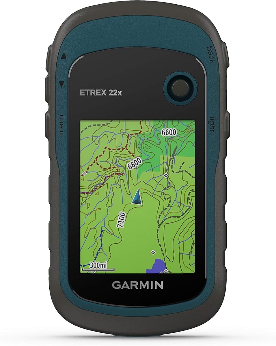
The Garmin eTrex 22x is a reliable navigator for boaters on a budget who still want durability. It has a 4.3 rating reflecting user satisfaction with its performance and longevity. The unit is rugged and easy to read in bright sunlight.
We may earn a commission when you buy through this link, at no additional cost to you.
It features a 2.2-inch sunlight-readable color display with 240 x 320 pixels. Preloaded Topo Active maps include routable roads and trails for versatile use. GPS and GLONASS support ensures tracking in challenging environments. Internal memory holds 8 GB for map downloads.
Battery life reaches 25 hours in GPS mode using 2 AA batteries. This is excellent for extended trips where charging options are limited. The micro SD card slot allows for expandable storage options. While not marine-specific it handles water sports well.
Consider this device for casual boaters or those who need a backup unit. Its affordability and battery life make it a practical choice for budget-conscious buyers. It is best suited for inland waters where detailed marine charts are less critical.
Using standard AA batteries allows for easy replacement during long expeditions. This design reduces reliance on complex charging systems.
The micro SD card slot enables you to download additional maps as needed. This flexibility supports diverse navigation requirements.
We may earn a commission when you buy through this link, at no additional cost to you.
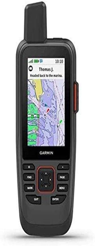
The Garmin GPSMAP 86Sci represents the pinnacle of connectivity and charting for serious marine navigation. With a 4.2 rating it appeals to boaters needing advanced communication and control features. This handheld integrates seamlessly with your existing marine system.
We may earn a commission when you buy through this link, at no additional cost to you.
It preloads BlueChart G3 coastal charts for detailed navigation. Inreach satellite communication allows two-way text messaging via the Iridium network. You can trigger an interactive SOS to search and rescue centers with a subscription. This device streams boat data from compatible chartplotters to consolidate info.
Functionality includes acting as a remote control for autopilots and Fusion Marine products. Adjustable GPS filters smooth speed and heading over swells. The water-resistant floating design ensures safety on deck. Display visibility is optimized for sunlight conditions.
This model is best for captains who need safety messaging and system integration. While the subscription cost is a factor the safety features justify the expense. Choose it if you want a handheld that communicates with other onboard electronics.
Inreach allows two-way communication in remote areas without cell service. This critical safety feature can be a lifesaver during emergencies.
Streaming data from other instruments creates a unified view of your vessel. This integration reduces the need for multiple separate screens.
We may earn a commission when you buy through this link, at no additional cost to you.
The Garmin GPS 73 is tailored for sailors who need specialized features like tack assist and starting lines. It holds a 4.4 rating for its ease of use and specialized functionality. This model focuses on the specific needs of racing and cruising sailors.
We may earn a commission when you buy through this link, at no additional cost to you.
Sail assist features include virtual starting lines countdown timers and speed history. Man Overboard alarms and anchor drag alerts provide essential safety. The interface is intuitive with dedicated backlit buttons for quick operation. You can store 1,000 waypoints and 100 tracks.
Battery life reaches 18 hours on 2 AA batteries which is solid for daily use. The 2.6-inch display provides clear reading for navigation data. Marine features are robust for a budget-friendly unit. It is simple to learn and operate quickly.
Consider this unit for competitive sailors who need timing tools and alerts. It is less feature-rich than marine GPS units but excels in sailing functions. Ideal for those who prioritize performance metrics over detailed charting.
The tack assist and starting line tools help racers optimize their performance. These specialized metrics are rarely found in standard GPS units.
MOB and anchor drag alarms provide immediate alerts to potential dangers. These features are crucial for ensuring crew safety on the water.
We may earn a commission when you buy through this link, at no additional cost to you.
The Garmin GPSMAP 79sc Renewed offers the same premium features as the new model at a lower price point. With an impressive 4.8 rating users appreciate the value and reliability of this refurbished unit. It retains the original marine chart and float capabilities.
We may earn a commission when you buy through this link, at no additional cost to you.
It includes all the key features of the new model including BlueChart g3 charts and multi-satellite support. The unit is tested to ensure it meets factory specifications for performance. This allows you to access high-end marine tech without the premium cost.
The design remains rugged and water-resistant with IPX6 certification. It floats in water and includes a high-resolution display. Battery life remains at 20 hours in GPS mode. The compass and altimeter function as expected for navigation.
Choose this option if you want the top features but prefer a budget-friendly approach. It is a smart choice for cost-conscious boaters who need quality. Verify the warranty details before purchasing to ensure peace of mind.
This renewed unit provides the same utility as new models for less money. It is an excellent entry point into premium marine navigation.
Certified refurbished products are tested to work like new. You get the benefits of a full-featured device without the high cost.
We may earn a commission when you buy through this link, at no additional cost to you.
The Garmin GPSMAP 65 delivers exceptional accuracy through its multi-band technology and expanded GNSS support. With a 4.5 rating it satisfies users needing precise tracking in challenging environments. This unit is ideal for navigating complex coastal areas.
We may earn a commission when you buy through this link, at no additional cost to you.
Its large 2.6-inch sunlight-readable color display makes it easy to view maps and waypoints. TopoActive mapping covers federal public lands for versatile use. The multi-band technology improves accuracy in steep country or dense forests. You can manage tracks and routes easily via the Explore app.
Button operation ensures control is maintained even with wet gloves or hands. The device includes federal public land maps which may not be critical for offshore use. This is a robust option for navigation in difficult terrain or coastal zones.
Choose this device if precision is your top priority over charting. It offers the best signal reception in this class. Ideal for boaters who navigate near coastlines or in areas with signal interference.
Multi-band technology helps filter out interference for better signal precision. This is useful in areas with tall trees or high buildings.
The Garmin Explore app allows you to manage routes on your phone. This streamlines the planning process before heading out.
We may earn a commission when you buy through this link, at no additional cost to you.
The Garmin eTrex 32x is a rugged navigator that adds a 3-axis compass and barometric altimeter. It has a 4.2 rating from users who appreciate its durability and tracking abilities. This model is solid for those who need orientation tools.
We may earn a commission when you buy through this link, at no additional cost to you.
It features a 2.2-inch sunlight-readable display with clear pixel resolution. Topo Active maps allow for easy route planning. GPS and GLONASS support ensures reliable tracking. Internal memory includes 8 GB plus a micro SD card slot for expansion.
The barometer tracks pressure changes which is useful for weather forecasting. The compass provides accurate heading even when stationary. Battery life reaches 25 hours in GPS mode using 2 AA batteries. This longevity supports long-duration trips.
Consider this device for outdoor enthusiasts who need reliable compass and altitude data. It is a great backup unit for navigation without a subscription. Ideal for boaters who value altitude and weather tracking alongside GPS.
The barometric altimeter can help anticipate weather changes before they happen. This adds a layer of safety to your navigation tools.
A 3-axis compass provides accurate heading information at any tilt angle. This is useful when you need to orient yourself quickly.
We may earn a commission when you buy through this link, at no additional cost to you.
The Garmin eTrex SE is an affordable and reliable choice for basic navigation needs. With a 4.2 rating it offers solid performance for those on a budget. This model prioritizes long battery life and water resistance.
We may earn a commission when you buy through this link, at no additional cost to you.
It features a 2.2-inch high-resolution display that reads well in sunlight. The water-resistant design is rated to IPX7 which protects against immersion. Multi-GNSS support includes GPS GLONASS Galileo BeiDou and QZSS for better tracking. The digital compass shows heading even when stationary.
Battery life reaches 168 hours in standard mode and 1,800 hours in expedition mode. This makes it ideal for long camping or boating trips. Pairing with the Explore app allows for wireless updates and trip planning. This is a practical entry-level navigator.
Consider this model for casual boaters or beginners. It offers essential features without a high cost. Best for those who need a simple reliable backup for open water.
The expedition mode allows for over a year of battery life in tracking mode. This is unmatched for long-term tracking needs.
IPX7 rating means the device can survive submersion in water. This is a critical feature for any marine handheld.
We may earn a commission when you buy through this link, at no additional cost to you.
The Garmin GPS 76 is a simple reliable unit for basic navigation tasks. It carries a strong 4.6 rating reflecting its durability and ease of use. This device is ideal for those who need straightforward location tracking.
We may earn a commission when you buy through this link, at no additional cost to you.
It includes WAAS enabled technology to improve accuracy significantly. The unit tracks up to 12 satellites simultaneously. The trip computer provides current speed and trip distance. It uses 2 AA alkaline batteries for up to 16 hours of use.
This model is basic but effective for point-to-point navigation. It allows for memory data downloading via optional software. The interface is simple enough for anyone to learn quickly. It serves well as a backup unit on board.
Consider this device for budget-conscious users needing essential tracking. It lacks advanced charts but gets the job done for location. Ideal for those who rely on paper maps or separate chartplotter systems.
WAAS improves GPS accuracy to within a few meters for better precision. This is beneficial when navigating narrow channels.
The straightforward interface reduces the learning curve for new users. You can focus on the water rather than complex menus.
We may earn a commission when you buy through this link, at no additional cost to you.
Choosing the right handheld GPS for boating requires evaluating several factors to ensure it meets your specific navigation needs and environment.
Look for a unit with at least an IPX6 rating to withstand rain and splashes. Some models offer floating designs to prevent loss overboard. Durability ensures the device survives rough weather conditions without failure.
Prioritize water-resistant and floating units for maximum safety on deck.
A sunlight-readable display is essential for viewing maps and waypoints in bright conditions. Scratch-resistant and fogproof glass improves longevity in humid environments. High-resolution screens make it easier to read details at a glance.
Choose a display that remains visible without glare or distortion under sunlight.
Marine-specific chartpreloaded are critical for coastal navigation to avoid hazards. Some units include BlueChart g3 or Topo Active maps for immediate use. Without these you may need to purchase additional map files separately.
Opt for devices with preloaded marine charts to save time and money.
Long battery life ensures the device stays on during extended trips. AA battery models allow for quick replacement while rechargeable ones offer convenience. Consider your typical trip length when evaluating hours of operation.
Select a unit that supports your longest planned trip without needing a recharge.
Multi-satellite systems like GPS GLONASS and Galileo improve accuracy in challenging areas. More satellites mean better positioning when signals are weak or blocked. This feature is vital for offshore or coastal navigation.
Choose a device with broad satellite support for reliable global tracking.
Features like Man Overboard alarms or SOS messaging can be lifesaving in emergencies. Compass and altimeter tools help track direction and elevation changes. Satellite communication adds security for remote waters without cell service.
Look for safety alerts and communication options to enhance your security on the water.
Some GPS units can link with other marine electronics to streamline navigation. Ability to stream boat data or control autopilots increases functionality. Bluetooth connectivity allows pairing with smartphones for updates.
Choose a model that integrates with your existing marine system for ease of use.
An intuitive interface ensures you can operate the device quickly without distraction. Button-operated models are better than touchscreens when wearing gloves or hands are wet. Simple menus reduce the time spent searching for functions.
Prioritize a design that allows for quick and reliable operation in rough conditions.
Start by inserting fresh batteries or charging the device fully before your trip. Power on the unit and allow it to acquire satellite signals in an open area away from metal objects. Once it shows a lock mark your current position as a waypoint if needed.
Input your destination into the device using either manual entry or a planned route. Follow the bearing arrow on screen to stay on course while adjusting for wind and currents. Check the battery life periodically to ensure you do not run out of power.
After returning to shore rinse the GPS with fresh water to remove salt and sand. Dry the unit thoroughly before storing it in a cool dry place away from direct sunlight. Update the software regularly to ensure the latest maps and features remain active.
Some devices come with preloaded charts like BlueChart g3 so no subscription is needed for basic use. Other models may require you to purchase maps separately or subscribe to cloud updates. Always check the included mapping features before buying.
Yes if the unit is water-resistant and floats to prevent loss. Look for units with IPX6 or IPX7 ratings and a rugged build. These designs ensure the device can handle spray and accidental drops.
Most models offer 18 to 25 hours of battery life on standard AA batteries. Some units can extend to several days with power-saving modes. Consider your trip duration when selecting the battery capacity.
Use the Waypoint feature to save your current location and assign a name. You can then view this spot on your screen for easy navigation back to it. Most devices allow you to create a route between waypoints.
A compass helps show your heading even when you are stationary or moving slowly. This is useful when trying to orient yourself on a calm day or narrow channel. Many modern handhelds include a 3-axis tilt-compensated compass.
Some advanced models can stream boat data and integrate with Garmin chartplotters. This creates a unified system to reduce clutter and improve readability. Verify compatibility before purchasing to ensure it matches your existing equipment.
We highlighted the top handheld GPS options for boaters including the GPSMAP 79sc and eTrex SE. These units offer a mix of chart coverage durability and battery performance for different needs.
Prioritize water resistance and map quality to ensure you stay safe on the water. The best device depends on whether you value premium features or budget affordability most.
Prices and availability change often so check current listings before making your final decision. Use this guide to compare specs and choose a reliable tool for your next adventure.